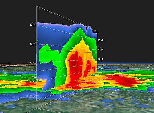
WFOR CBS4 just launched a new cool weather radar this Thursday! They call it Doppler 4D, and it’s like nothing else in the South Florida TV news market. According to Craig Setzer’s Inside Weather Scoop Blog:
“A typical radar view is two dimensional. It is also typically the lowest “slice” out of a thunderstorm and indicates the intensity of rain (or possibly hail) falling out of the storm. If you loop the image you add the dimension of time and how the storm is changing over time. This, in some respects is three dimensions. We can also look at a radar image in the form of a “range height indicator” or RHI. Then you not only see a horizontal slice of the storm, but a vertical slice as well.”
“[…] So simple intensity of the storm is important and that’s what most radars show, but Doppler 4D shows the entire depth of the storm, revealing details we rarely see. Potential hail, extreme winds, even tornadoes show up when viewed in this much detail.”
With hurricane season already a month old, and a tropical weather system inevitable, this may be an edge WFOR needs. It seems to be common knowledge that WTVJ doesn’t have a chance in hell of gaining any viewers this hurricane season with their (small) all-star weather team – but WFOR has a chance. Read more of this personal opinion in the SFLTV Forums.
It’s so good to see WFOR, a station making huge cutbacks and laying off people left and right–finding funds in their tight budget for a “Cool New Radar”. Bravo! That’s just super!
Actually, WPEC in West Palm got the same radar display technology a few months back. It’s called “X-vision”.
Yeah we’ve been using the same tool for about a year. Neat, we can cut through a storm. Here’s a hail core. I would hardly use this to identify tornadoes, but whatever floats your boat…especially in sofla with lower level, weak rotation in most tornadic events.
Of course weather guys don’t mind having more toys to play with and the ability to say “my toys are better than your toys”. Looks cool, and it’s another promotional tool, but I don’t think any single gadget can snag a bunch of viewers.
They can’t go HD, but they can go 4D… Nice, FOR, nice…
Is this simmilar to Titan HD 3D.
how about a radar that finds jobs for their former employees…
You can get the same thing on your on computer. It’s called GR2Analyst. http://www.grlevelx.com. I use the same software on my computer for my own personal weather website during severe weather. TWC uses the same software during severe weather coverage. WFOR must be using this software now as well.
The X-Vision which was referred to above, that WPEC is using, is thru WeatherCentral…and has been implemented into their own doppler technology.
Craig Setzer = THE MAN of south florida weather knowledge. he knows his stuff, knows has to keep it simple for all the common folk. if you’re looking for weather know-how….skip 7 and 10 and head to 4.
Craig Setzer is the man!
As Ryan said Weather Central has been putting this out for years. I believe WPLG and WSVN used it three years ago during their hurricane coverage when Weather Central rolled it out.
I’m not from S FL (from the Boston area) but it definitely seems like 4 has the most experienced weather team. David Bernard and Craig Setzer seem great.
Hi there, simply became aware of your blog through Google, and located that it’s truly informative. I am going to be careful for brussels. I’ll appreciate when you proceed this in future. A lot of people will likely be benefited out of your writing. Cheers!